Unveiling Bandung’s Lost Lake: The Forgotten Tale Beneath the City

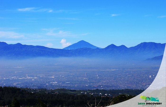
javadiscovery.com – Under the restless rhythm of Bandung’s traffic and the gleam of modern cafés, lies a forgotten chapter of Earth’s memory. Long before the city earned its title as Indonesia’s creative hub, it was once swallowed by water—a colossal lake known today as Lake Bandung or Danau Bandung Purba. Hidden beneath the soil and skyline, its traces whisper stories that stretch back hundreds of thousands of years.
The Birth of a Giant Lake — From Volcanoes to Valleys
According to geologist T. Bachtiar, author of Peta Danau Bandung Purba, the story began roughly 560,000 years ago when Mount Jayagiri erupted in what is now the Bandung Basin. The explosion was so powerful that the mountain collapsed inward, forming a massive caldera—a depression born from a volcanic void. This caldera later became the stage for an even greater geological drama.
Hundreds of thousands of years later, a new titan emerged: Mount Sunda, soaring nearly 4,000 meters from base to peak. Around 105,000 years ago, its cataclysmic eruption sent shockwaves across the land. Ash, lava, and pyroclastic flows buried rivers and valleys, damming the ancient Citarum River and trapping immense volumes of water. The result was breathtaking—a lake stretching from Cicalengka to Cimahi, vast enough to make today’s Saguling Dam seem miniature by comparison.
The Collapse — How the Ancient Lake Disappeared
For millennia, Lake Bandung lay calm and deep, reflecting the surrounding mountains—Tangkuban Parahu, Manglayang, and Burangrang. But nature is never still. Eventually, the dam that confined the waters began to fail. Bachtiar explains that the volcanic barrier likely crumbled due to earthquake activity and fault movement around Nanjung and Curug Jompong.
“It wasn’t just erosion,” Bachtiar noted. “Earthquakes shook the natural dam until it collapsed.” Contrary to local belief, the break did not occur at Sanghyang Tikoro—a cave-like channel in West Bandung—but near Curug Jompong, where geological elevation aligns with the lake’s former water level. When the dam burst, torrents carved a new path for the Citarum River, draining most of the lake and transforming the region into fertile plains and shallow wetlands.
Traces of the Ancient Lake — Geology Hidden in Plain Sight
Though the waters are gone, Lake Bandung’s skeleton remains etched in stone. You can still find clues scattered across the city’s landscape:
- Curug Sigay — volcanic debris from Mount Sunda’s ancient eruption still lines this waterfall behind UPI campus.
- Tahura Djuanda — flows of lava pahoehoe, smooth and ropelike, reveal how molten basalt once streamed across Dago’s forests.
- Kapulaga and Ciater — pockets of volcanic rock and thermal springs mark the northern rim of the vanished lake.
Each site is more than a tourist stop—it’s a living archive of Earth’s restless creativity, preserved beneath Bandung’s modern face.
Climbing the Past — When Hikers Become Storytellers
While Bachtiar maps the past with data, Gan-gan Djatnika brings it to life through footsteps. A veteran mountaineer who has climbed over 70 peaks around Bandung, he leads geo-trekking tours that blend adventure with education. “Hiking isn’t just about endurance,” he says. “It’s about reading the stories written in stone.”
During the pandemic, Djatnika climbed Mount Papandayan and the ancient hills of Baleendah, tracing the contours of the Bandung Basin from above. From the summit, he could see how the surrounding mountains—Manglayang to Tangkuban Parahu—once formed the lake’s perimeter. Through his campaign #AtapTertinggiCimahi, he encourages locals to protect Mount Padakasih, the ridge that once divided the eastern and western basins of the lake, from excessive mining.
“Maybe we can’t fix the damage of the past,” he says, “but we can stop it from getting worse.”
In every expedition, Djatnika reminds hikers that every rock has a role in the island’s long memory—from the potholes of Curug Jompong carved by swirling waters, to the prehistoric caves of Gua Pawon that once housed ancient humans. For him, geology is poetry, and the mountains are verses waiting to be read aloud.
Conclusion — What Bandung Can Teach Us
Bandung’s ancient lake may be gone, but its legacy endures—in the hills, the soil, and the stories of those who walk upon it. To explore Bandung is to explore the Earth’s own autobiography, a tale of creation, destruction, and rebirth. Understanding its geological past is more than science—it’s a call to care, to protect, and to listen.
As Djatnika beautifully puts it, “When we hike with knowledge, the mountain stops being just a view—it becomes a teacher.”