Semeru’s 2025 Eruption Sends Panic Across East Java
javadiscovery.com – The Semeru 2025 eruption began as a sudden roar over the high spine of East Java, followed by a towering grey plume that rose from the summit. Within minutes, villages across Lumajang felt the tremors, and reports from monitoring stations confirmed a major volcanic event was underway. What began as a column of ash quickly turned into one of Semeru’s most intense episodes in recent years.
A Violent Eruption That Shook East Java
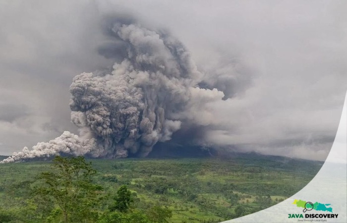
On November 19, Semeru released a massive burst of ash and volcanic material that darkened the sky over the southern slopes. Seismographs at the observation post recorded a maximum amplitude of 40 mm with a duration of more than 16 minutes. From afar, the plume resembled a wall of ash drifting slowly toward villages that had already experienced eruptions in recent years.
Pyroclastic Clouds Sweeping 5.5 Kilometers
The eruption sent pyroclastic clouds surging down the mountainside for 5.5 kilometers toward the Besuk Kobokan channel. Thick grey ash drifted northwest to north, creating low visibility and coating nearby villages. Residents reported the smell of sulfur filling the air, while emergency units observed rolling clouds of hot debris sweeping through the valley floor.

Activity Level Raised to the Highest Alert
The Geological Agency upgraded the activity status of Semeru to Level IV (Awas), the highest emergency level. Authorities urged the public to avoid the southern–southeastern sector within an 8-kilometer radius from the summit. The warning included the possibility of more pyroclastic flows, lava avalanches, and lahars along river valleys that originate from the peak of Semeru.
Panic at Gladak Perak as Ash Clouds Rushed In
Videos circulating online captured the chaotic scenes near Gladak Perak Bridge. As the pyroclastic cloud advanced up to 13 kilometers along Curah Kobokan and Kali Lanang, people began shouting warnings to one another. Motorcyclists sped away, families called out to relatives, and villagers rushed uphill to escape the cloud’s path. The noise of the eruption echoed through the valley, amplifying the panic.
In nearby settlements such as Kamar Kajang and Supit Urang, residents quickly abandoned their homes. Miners working along the rivers ran to safety, leaving their equipment behind. For many, the moment felt eerily similar to previous eruptions that reshaped parts of Lumajang’s landscape.
Trekking Routes Closed Following the Eruption
The Bromo Tengger Semeru National Park Authority (TNBTS) announced a full closure of all Semeru trekking routes. This includes the popular trail leading to Ranu Kumbolo. The decision follows recommendations from PVMBG and aims to protect hikers and local communities from potential secondary events such as aftershocks or renewed pyroclastic activity.
Lumajang Declares a Seven-Day Emergency Response
The Lumajang Regency issued an official emergency decree valid for seven days, from November 19 to 25. Village leaders were instructed to coordinate evacuations, prepare temporary shelters, and maintain communication with response teams. The decree emphasized swift and coordinated action, especially for residents in areas with a history of heavy ashfall.
178 Hikers Stranded at Ranu Kumbolo
At the time of the eruption, 178 hikers were stranded at Ranu Kumbolo, a lake situated along the popular Semeru hiking route. The National Disaster Management Agency (BNPB) deployed evacuation teams led by senior officials to guide the hikers to safety. Meanwhile, more than 300 residents sought refuge across three temporary shelters: Oro-Oro Ombo Village Hall, Penanggal Village, and Supiturang Elementary School.
As evacuation efforts continue, authorities report no confirmed casualties. However, the scale of the Semeru 2025 eruption underscores the need for constant vigilance on Java’s volcanic front—an island shaped and shaken by the forces beneath it.
Java’s mountains have always been dramatic, but Semeru’s sudden fury in 2025 is a reminder of how quickly the landscape can change, and how closely communities live with both its beauty and its risks.