Forgotten Canals of Old Semarang Maritime Trade Infrastructure Kota Lama

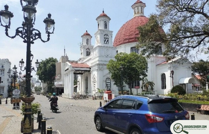
javadiscovery.com – Today, visitors walking through the atmospheric, colonial-era streets of **Kota Lama** (Old Semarang) encounter a European-styled enclave often nicknamed “Little Netherland.” With its grand neoclassical facades, shady cobblestone squares, and towering churches, the district presents a picture of 19th-century European urban planning set against the Javanese tropics. Yet, beneath the tarmac, storm drains, and modern foundations lies a much older, more complex architectural reality. Long before Semarang became a brick-and-mortar European fortress, it was a water-locked delta city. The Dutch East India Company (VOC) and later colonial administrators did not merely build upon dry land; they carved an intricate network of navigable canals (*Kali*) directly into the swampy marshes of the Semarang River basin, transforming a tidal estuary into the maritime commercial powerhouse of Central Java.
The forgotten canals of Old Semarang served as the vital economic veins of the city, connecting interior trade routes with international shipping lanes before silting and modernization paved over their watery paths.
The Delta Crucible: Engineering a Fortified Port City
When the VOC established its trading factory in Semarang during the late 17th century, the coastal geography was treacherous and unstable. Dominated by shifting mangrove swamps, tidal floods (*rob*), and heavy silt deposits carried down by the Semarang River, the site was hostile to permanent stone construction. To secure control over the lucrative spice and agricultural trade pouring out of the Central Javanese interior, Dutch engineers implemented a familiar blueprint borrowed from Amsterdam:
- The Moated Fortress (Vijfhoek): The earliest VOC settlement was a five-pointed wooden and earthen fortification (*Fort de Vijfhoek*) strategically positioned near the river mouth to control maritime access.
- Grid Canal System: As the settlement expanded into the walled European quarter (*Oud Semarang*), engineers dredged straight, geometric canals that doubled as defensive moats, urban drainage channels, and cargo transport lanes.
- Taming the Tides: Sluice gates, wooden locks, and brick river embankments were constructed to control seasonal floodwaters and prevent tidal surges from inundating merchant warehouses (*gudang*).
The Waterways of Commerce: How Goods Moved Through Kota Lama
During the 18th and 19th centuries, Kota Lama was not a pedestrian district of stone walks; it was a bustling aquatic marketplace where flat-bottomed lighters (*prahu*) and European barges navigated narrow canals directly to the doorsteps of commercial godowns:
- The Kali Semarang Arteries: The main channel of the Semarang River and its dredged canal offshoots functioned as the primary highway for offloading bulky interior commodities—such as bags of sugar, coffee beans, tobacco, and teak timber—transported down from the Vorstenlanden (Surakarta and Yogyakarta).
- Warehouse-to-Ship Logistics: Wealthy trading houses (*Factorijen*) like the Javasche Bank, Geo Wehry & Co., and Nederlandsche Handel-Maatschappij (NHM) maintained private water gates where goods were hoisted directly from canal barges into elevated multi-story storage vaults.
- Cosmopolitan Waters: The canals were alive with diverse maritime cultures. Chinese junk sailors, Malay boatmen, Arab traders, and European customs officers navigated the same waterways, creating a vibrant, polyglot port culture.
The Silting Crisis and the Death of the Canals
The very geography that made Semarang a great port ultimately contributed to the eclipse of its canal network. Java’s intense deforestation, driven by intensive colonial agriculture and upland plantation expansion, triggered massive soil erosion. Millions of tons of silt washed down river channels every rainy season:
- Choking the Waterways: By the late 19th century, the inner canals of Kota Lama were perpetually clogged with mud. Larger merchant vessels could no longer navigate the shallow, choked channels, creating a severe economic bottleneck.
- The Shift to Outer Harbors: To save Semarang’s maritime trade, the colonial government abandoned the inner canal system, commissioning the construction of the massive modern Semarang Harbor (*Pelabuhan Tanjung Mas*) further out to sea in the early 20th century.
- Paving Over History: As sanitation concerns grew regarding stagnant water and tropical diseases like cholera and malaria, municipal authorities systematically filled in many of Kota Lama’s historic canals, converting them into paved streets, tram lines, and underground drainage culverts.
Rediscovering the Subterranean Maritime Heritage
Though the surface canals were buried, their presence is never truly gone. Heavy monsoon rains regularly trigger modern tidal flooding (*rob*) in Kota Lama—a natural reminder that the district remains a reclaimed wetland built upon delta silt.
In recent years, urban revitalization projects and archaeological surveys in Semarang have begun uncovering forgotten brick culverts, ancient stone quays, and historic water gates buried beneath the streets of Kota Lama. Preserving these hidden maritime structures allows historians and travelers to look past the European facade and appreciate the true engineering feat: a Javanese delta city built on water.