The Disappearing North Coast of Java
javadiscovery.com – At dawn, the tide creeps into the narrow alleys of a fishing village on Java’s northern shore. It moves without urgency, without drama. The water is brown and reflective, carrying fragments of leaves, plastic wrappers, and the faint scent of brine mixed with diesel. Roosters still crow from rooftops that now stand like small islands. A child wades barefoot to school, uniform lifted above the knee. The sea does not roar here. It advances quietly.
Where the Land Meets a Restless Sea
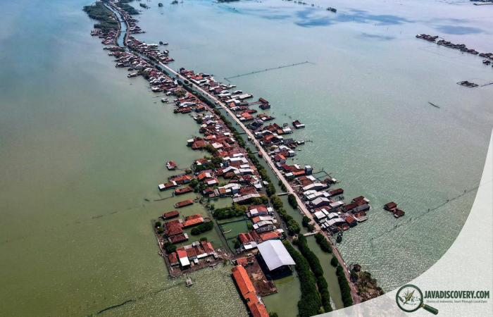
The north coast of Java, often called Pantura, stretches from Banten in the west to East Java’s long arc facing the Java Sea. It is one of Indonesia’s most densely populated corridors. Ports, factories, fish markets, highways, and centuries-old settlements line this flat, low-lying plain. Historically, it has been a gateway of exchange. Traders from China, Arabia, India, and Europe once anchored along these waters, shaping the island’s cultural and economic trajectory.
Today, the shoreline tells a different story. Concrete sea walls rise where mangroves once stood. Abandoned houses tilt at uncertain angles, their foundations weakened by saltwater intrusion. Roads are patched repeatedly, only to crack again. In some neighborhoods, the ground sinks by several centimeters each year. The sea level rises, but the land also descends. The effect is cumulative and relentless.

The Science Beneath the Silence
The disappearing coast is not driven by a single force. It is the convergence of land subsidence, sea level rise, coastal erosion, and intensive human development. In cities like Jakarta, Semarang, Pekalongan, and Demak, groundwater extraction has hollowed out the earth beneath urban settlements. As freshwater is pumped upward to meet industrial and domestic demand, the soil compacts. The surface lowers. The ocean does not need to rise dramatically when the land itself is sinking.
Alongside subsidence, global sea levels have steadily increased due to climate change. Warmer oceans expand. Glaciers melt. The Java Sea, once perceived as a stable horizon, now presses more insistently against the shore. Seasonal high tides known locally as rob flood streets and homes, sometimes without rainfall. What used to be an annual event becomes monthly, then weekly.
In Demak Regency, entire stretches of coastline have retreated hundreds of meters over the past decades. Fishponds are swallowed. Cemeteries erode. Maps grow outdated faster than they can be redrawn.
Villages on the Edge
In Bedono village, Central Java, the call to prayer echoes across open water where rice fields once lay. The mosque stands isolated, reachable only by wooden walkways built by residents and volunteers. Its white walls bear the stains of repeated inundation. The floor tiles feel cool and damp even under the midday sun.
Pak Suyanto, a fisherman in his late fifties, recalls when motorcycles could pass in front of his house. Now, he keeps a small wooden boat tied to his veranda. “The sea was far,” he says, gesturing toward the horizon that now begins at his doorstep. “We planted coconut trees there.”
His memory is not dramatic. It is observational. Over time, the shoreline shifted. First the fishpond embankments broke. Then the waves reached the road. Then saltwater seeped into wells, making drinking water scarce. Families moved inland when they could afford to. Those who stayed adapted. They elevated floors, built second stories, or constructed narrow bridges connecting homes above tidal water.
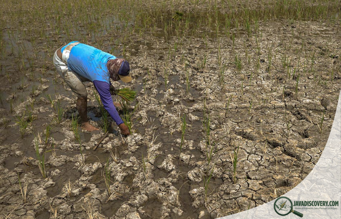
Salt in the Soil
The transformation is not only visible in submerged structures. It is felt in the soil. Saltwater intrusion contaminates agricultural land, reducing productivity. Rice paddies turn brackish. Farmers switch to aquaculture, raising milkfish or shrimp in ponds that once grew grain. Some succeed. Others struggle with fluctuating prices and disease outbreaks.
On the outskirts of Pekalongan, women who once tended vegetable plots now sort small anchovies on raised bamboo platforms. Their hands move quickly, separating fresh catch from debris carried in by the tide. The air smells sharply of drying fish. The rhythm of work continues, even as the geography changes.
Urban Frontlines
Further west, the northern districts of Jakarta reveal the urban dimension of the crisis. Towering sea walls stand between neighborhoods and the Java Sea. Pumps operate day and night to remove water trapped by subsidence. In some places, the ground has sunk more than four meters over the past decades. Concrete barriers attempt to hold back the inevitable.
In Muara Baru, fishing boats painted in bright blues and reds crowd the harbor. The harbor floor itself must be dredged repeatedly as sediment accumulates. Fishermen speak of unpredictable tides and shifting currents. “Sometimes the water comes faster than we expect,” says Iwan, a boat captain who has worked these waters since his youth. “We watch the moon, but now the patterns are different.”
Urban planners debate long-term solutions. Some propose giant coastal barriers. Others emphasize restoring mangroves and reducing groundwater extraction. The challenge lies not only in engineering but in governance, enforcement, and social equity. The north coast is not empty land. It is home to millions.
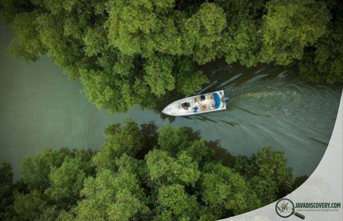
Mangroves as Memory and Defense
Before concrete dominated the shoreline, mangrove forests buffered waves and stabilized sediment. Their tangled roots created nurseries for fish and crustaceans. In recent decades, large portions were cleared for fishponds, ports, and development.
Now, replanting efforts emerge along segments of the coast. In parts of Demak and Indramayu, community groups wade knee-deep into mudflats, pressing young mangrove saplings into place. The work is slow and physically demanding. The mud sucks at boots. The sun bears down. Yet over time, green shoots take hold.
Mangroves alone cannot reverse subsidence or global sea level rise. But they reduce wave energy and trap sediment, gradually building land. In some pilot areas, newly formed mudbanks stretch outward, suggesting that nature still negotiates with the sea when given space.
Heritage at Risk
The north coast is not only an economic artery. It is a cultural corridor. Historic port towns such as Cirebon, Tuban, and Lasem carry layered identities shaped by maritime trade. Wooden houses with Chinese architectural influences stand alongside Javanese joglo structures and colonial-era buildings.
In Lasem, known for its distinctive batik patterns, artisans work in courtyards where dye vats release earthy, metallic scents. The proximity to the coast has long defined trade routes and aesthetic exchange. Yet increased flooding threatens both physical structures and intangible practices. Fabric stored in ground-level workshops can be damaged by sudden tidal water. Repeated exposure to humidity affects wooden beams and carved details.
Coastal cemeteries that hold generations of memory erode gradually. Headstones tilt. Families relocate remains when possible, though not all can afford to do so. The loss is not always dramatic enough to make headlines. It unfolds quietly, one plot at a time.
Migration and Adaptation
As the coastline shifts, so do demographic patterns. Younger residents often seek work inland or in larger cities. Remittances support relatives who remain. In certain villages, classrooms shrink as families relocate. In others, new settlements form slightly farther from the sea, repeating the cycle of development on fragile ground.
Adaptation takes many forms. Houses are built on stilts. Roads are elevated. Community members organize rotating schedules to repair embankments. Some local governments invest in polder systems that combine dikes, retention basins, and pumps. These measures provide temporary relief, buying time.
Time, however, is a complex commodity. Climate projections indicate continued sea level rise throughout the century. Without significant reduction in groundwater extraction, subsidence persists. The interplay between global climate forces and local policy decisions determines the pace of change.
Listening to the Coast
On a late afternoon in Semarang, the sky turns copper as the sun lowers behind industrial cranes. The tide is receding, leaving behind shallow pools that reflect warehouse walls and passing clouds. Children chase small fish trapped in puddles. Laughter cuts through the humid air.
An elderly woman sits on a bench outside her home, watching the water withdraw. She speaks softly about her childhood, when the shoreline was a field away and evenings smelled of wet earth rather than salt. “The sea gives,” she says. “But it also takes.”
Her words capture a long-standing relationship between Javanese communities and the ocean. The north coast has always been dynamic, shaped by monsoons, trade winds, and sediment flows from rivers descending from volcanic highlands. Change is not new. The scale and speed of the current transformation, however, challenge established rhythms.
The Future Written in Tides
The disappearing north coast of Java is not a distant abstraction. It is visible in cracked walls, saline wells, altered livelihoods, and modified maps. It is measurable in centimeters of sinking ground and millimeters of rising sea. It is felt in the cautious calculations families make about rebuilding or relocating.
Experts emphasize integrated solutions. Reducing groundwater dependence through improved piped water systems could slow subsidence. Protecting and expanding mangrove belts strengthens natural defense. Thoughtful urban planning limits development in the most vulnerable zones. International climate mitigation influences long-term sea level trajectories.
Yet beyond technical strategies lies a human narrative. The north coast is a tapestry of fishermen mending nets at sunrise, traders negotiating prices in humid markets, children navigating flooded alleys, and elders recalling a shoreline that once lay farther away. The sea reshapes geography, but it also reshapes identity.
As night falls over Pantura, lights from houses and factories shimmer across tidal water. The boundary between land and sea blurs in darkness. Somewhere beyond the visible horizon, currents move steadily. Along Java’s northern edge, communities remain attentive, adapting day by day to a coast that is slowly, almost imperceptibly, slipping away.